 Click to view posters in PDF format.
Prediction and Mapping of Deep-Water Slope Carbonate Reservoirs Using Seismic Data, Tengiz Field, Western Kazakhstan*
By
Brent P. Francis1, L.J. (Jim) Weber1, Steve Bachtel1, Paul M. (Mitch) Harris2, Dennis Fischer3, and Jeroen A.M. Kenter4
Search and Discovery Article #20056 (2008)
Posted June 20, 2008
*Adapted from poster presentation at AAPG Annual Convention, Dallas, Texas, April 18-21, 2004.
1 ExxonMobil Development Company, Houston, Texas, U.S.A. ([email protected])
2 Chevron Energy Technology Company, San Ramon, California, U.S.A. ([email protected])
3 TengizChevroil, Atyrau, Kazakhstan; currently Chevron, San Ramon, CA ([email protected])
4 Free University, Amsterdam, Netherlands; currently ETC, Chevron, Voorburg, Netherlands ([email protected])
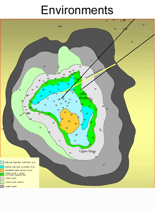
The supergiant Tengiz field of western Kazakhstan produces oil from an isolated carbonate platform (160 km2) of Devonian and Carboniferous age. An initial broad Late Devonian platform exhibits accentuated vertical growth with punctuated backsteps during the Lower Carboniferous (Tournaisian and Visean). The uppermost Lower Carboniferous (Serpukhovian) is characterized by several kilometers of platform progradation, seaward of the Late Visean platform break. Late Visean and Serpukhovian boundstone dominates slope lithofacies.
In situ upper slope microbial boundstone and allocthonous lower slope boundstone debris form thick and areally extensive mappable reservoirs with distinctive seismic facies and production characteristics. Areas dominated by boundstone exhibit lower porosity (<4%) than time equivalent grainy carbonates on the platform (8-12%), but they may have much higher permeability and flow capacity due to extensive fractures and dissolution. The highest rate wells (10,000 to 30,000+ barrels/day) are located at the platform margin and within the slope.
Because platform and slope production characteristics differ significantly at Tengiz, criteria are developed to identify, map, and assess volume of slope boundstone. Criteria include: 1) positive structural relief above thick upper slope boundstone, 2) chaotic reflection character frequently with high-amplitude bursts within both in situ boundstone and boundstone debris intervals, 3) mosaic distribution of seismic amplitude, 4) isopach thicks associated with boundstone intervals, and 5) slump scars indicative of slope failure. Criteria described here could be applicable to other similar hydrocarbon-bearing isolated platforms (e.g., Korolev and Kashagan) that extend from onshore western Kazakhstan into the offshore North Caspian Sea.
|
|
This study was a team effort. We sincerely thank the ExxonMobil “Tengiz team” for their hard work and many discussions of all aspects of Tengiz geology. Tom Kane analyzed well production data. Ray Garber and Phil Bassant (ChevronTexaco) provided core descriptions, which were instrumental in our work. We warmly thank Jeroen Kenter (Vrije Universiteit, Amsterdam), Paul Brenckle (Consultant), Jeroen’s knowledge of modern and ancient carbonate slope settings, and Paul Brenckle’s biostratigraphic data were invaluable to our studies. We also recognize the significant contributions of many additional people from ExxonMobil (M. Foster, M. Pierce,) and TengizChevroil (A. Azizi, P. Bateman, C. Brown, N. Dzhamikeshev, E. Furlin, J. Hohenberger, K. Nahm, O. Petrova, B. Robertson, L. Rowe, and A. Tyshkanbaeva). We thank TengizChevroil and its shareholder companies (ChevronTexaco, ExxonMobil, Kazmunaigaz, and BPLukArco) for support of our studies and permission to publish this poster. Special thanks to Paul Prestridge and Robert Benevente of the graphics department at ExxonMobil for the design and layout of this poster.
|

