|
uAbstract
uFigure
captions
uIntroduction
uRegional
setting
uDatabase
& methodology
uTectonic
elements
tForeland
basin . . .
tBurro
Negro  fault fault zone zone
tChaotic
zones
tEocene
Barinas basin
uPaleogene
evolution model
uReferences
uAbstract
uFigure
captions
uIntroduction
uRegional
setting
uDatabase
& methodology
uTectonic
elements
tForeland
basin . . .
tBurro
Negro fault zone
tChaotic
zones
tEocene
Barinas basin
uPaleogene
evolution model
uReferences
uAbstract
uFigure
captions
uIntroduction
uRegional
setting
uDatabase
& methodology
uTectonic
elements
tForeland
basin . . .
tBurro
Negro fault zone
tChaotic
zones
tEocene
Barinas basin
uPaleogene
evolution model
uReferences
uAbstract
uFigure
captions
uIntroduction
uRegional
setting
uDatabase
& methodology
uTectonic
elements
tForeland
basin . . .
tBurro
Negro fault zone
tChaotic
zones
tEocene
Barinas basin
uPaleogene
evolution model
uReferences
uAbstract
uFigure
captions
uIntroduction
uRegional
setting
uDatabase
& methodology
uTectonic
elements
tForeland
basin . . .
tBurro
Negro fault zone
tChaotic
zones
tEocene
Barinas basin
uPaleogene
evolution model
uReferences
|
Figure Captions
Return to top.
In Venezuela, a west-to-eastward younging pattern of thrusts and lateral
ramp faults are developed along the Caribbean - South American boundary
(Figure 1). In present-day Maracaibo basin, these lateral ramps and
thrusts are largely inactive, but exposed by later inversion related to
the North Andean orogeny. The main objectives are to illustrate the
overall structure of the Burro Negro fault, an exhumed Eocene age
lateral ramp fault exposed along the eastern edge of the Maracaibo
basin, by using a compilation of outcrop and subsurface observations
compiled from previous workers and regional 2D seismic data. These data
show that the Burro Negro fault, is rigth-lateral strike-slip in
character and separates an unthrusted, asymmetrical shallow to deep
basin from a thrusted area of deepwater sedimentary rocks.
Figure 2 shows the present-day configuration of the Maracaibo basin,
located in western Venezuela. The basin is a triangular depression
bounded by two main mountain ranges trending NE and NNE. The Sierra de
Perijá and Oca fault bound the basin to the west and north,
respectively. The Mérida Andes bounds the basin to the SSE. The Boconó
fault, a dextral strike-slip fault, follows the crest of the Mérida. To
the east the depression is bounded by the Trujillo Mountains, trending
NW-SE and ending near the Valera fault. East of the Trujillo Mountains
are the Lara nappes folded into an anticlinorium trending NE-SW
(Mathieu, 1989).
A regional time slice at 3400 ms, covering most of the Lake Maracaibo
area and part of the eastern alluvial plains, (Figure 2), intersects
Cretaceous to Miocene rocks. Prominent structural features within the
3400 ms time slice include NNE striking faults (e.g., Icotea and Pueblo
Viejo faults), formed during Jurassic rifting and reactivated as Eocene
strike-slip faults. Another family of east-west-striking faults is
observed, mainly in the central part of the basin. These faults were
previously interpreted as a flexural response to the subsidence of the
South American plate due to load of the Caribbean plate during the
Paleogene (Castillo, 2001). Two models for the structural evolution of
the Maracaibo basin and the development of the Eocene depocenter located
in the northeast-east have been proposed:
A) Foreland basin (Lugo, 1991; Audemard, 1991; Lugo and Mann, 1995): A
NE-dipping thrust front, located in the northern part of the basin and
Falcón area, controlled a parallel Eocene foredeep. The thrust front and
foredeep migrated southeastward with the emplacement of the Lara nappes.
B) Tear fault or lateral ramp or transversal (Stephan, 1985; Mathieu,
1989): A depocenter located SE of the tear fault or lateral ramp. The
tear fault allowed independent SE migration of the thrust front.
Terminal collision of the Lara nappes (Caribbean arc) and South America
continental crust led to emplacement of the Lara nappes, east of the
Maracaibo basin.
This study uses 2000 km2 of 3D seismic data, located at the
center of the Maracaibo basin, and approximately 500 km of 2D seismic
lines. Regional time slices, produced by merging many of the 3D seismic
surveys of the Lake Maracaibo area (Castillo, 2001), were also used.
Five deep exploratory wells located in the central and eastern parts of
the basin were tied to seismic data. A fence diagram shown in
Figure 3
orients the various tectonic elements interpreted in the eastern map of
the Maracaibo basin.
In the Maracaibo basin, lower Eocene rocks onlap the Paleocene
unconformity and back-step from north to south (Figure 3). Southward
migration of younger, onlap deposits over the Paleocene unconformity
indicates southward migration of the forebulge as subsidence increases.
By middle Eocene most of the Maracaibo basin was subaerially exposed.
Isostatic rebound and cessation of tectonic loading over the basin
suggests a termination of the Maracaibo foreland basin.
Return to top.
Burro Negro Fault Zone,
Platform Break and Lateral Ramp
Deeper Eocene rocks are to the NE from a stable shallower platform to
the SW. Gonzáles de Juana et al. (1980) defined a paleogeographic
boundary between the shallow marine environments to the south (platform
province) and basinal environments to the north, coinciding with the
mapped surface trace of the Burro Negro fault zone. Orientation of
Eocene convergence, west of the Burro Negro fault, indicates SW vergence
(Mathieu, 1989). Main depocenters were located in front of the folded
system during the end of the Eocene east of the Burro Negro fault
(Mathieu, 1989), where Paleocene-Eocene flysch and slumps have been
observed. Therefore, the Burro Negro fault area can be defined as the
shelf edge between the deep basin located to the NNE and the platform to
the SSW. The fault was reactivated by oblique collision of the Caribbean
coming from the west using the Burro Negro fault as a continental
bathymetric reentrant within the NE-trending South American plate
boundary where the Caribbean plate could be translated towards the SE,
acting as a lateral ramp between collided and uncollided parts of a
diachronously forming fold-thrust belt.
Structurally chaotic zones separate the Oligocene-Neogene sub-basins,
north of the Burro Negro fault. These chaotic zones exhibit
characteristics similar to those observed in highly fractured fault
zones or shale diapirs, where basinal shale is overpressured by the
Eocene-present compression.
The Eocene Barinas basin depocenter is separated by the Mérida Andes and
Boconó, and is located between 50 to 100 km southwest from the Eocene
Maracaibo depocenter. Horizontal displacement along the Boconó fault is
estimated to be more than 30 km and less than 100 km (Audemard et al.,
1999). Removal of Late Tertiary dextral motion along the Boconó fault
aligns the Barinas Eocene depocenter with the Eocene depocenter east of
the Burro Negro fault, south of the Lara nappes thrust front interpreted
by Stephan (1985).
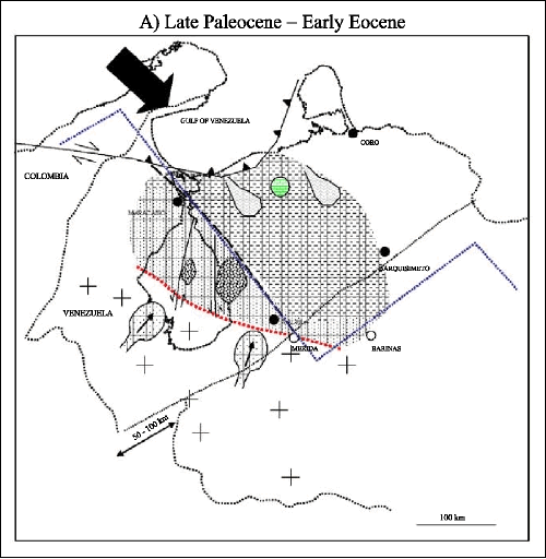
An integrated reconstruction of the evolution of the Maracaibo basin
during the Paleogene is summarized in Figure 4. Three main stages can be
described as follows:
a. Late Paleocene - early Eocene (Figure 4A): The Maracaibo basin begins
to downwarp as a response of tectonic loading in the north and northeast
as the Caribbean plate collides with northern South America. A flexural
bulge that formed in the central part of the basin migrated southward in
response to the thrust belt located in the north- northwest.
b. Middle - late Eocene (Figure 4B): Tectonic loading ends in central
and south Maracaibo basin, producing a regional unconformity by tectonic
rebounding. The thrust front begins to move southeastward, bounded to
the west by the Burro Negro fault in the northeastern part of the basin.
c. Late Eocene - Oligocene (Figure 4C): The Caribbean plate moves ESE
into the deepwater reentrant and induces strike-slip motion in the area;
coeval folding continues east of the Burro Negro fault.
d. Late Tertiary (Boconó fault; Figure 4D): Uplift of the Mérida Andes
during the Late Tertiary separates the Maracaibo basin from the Barinas
basin. Later motion along the Boconó fault displaces the Maracaibo basin
northeastward towards the Barinas Eocene depocenter.
Audemard, Felipe, 1991, Tectonics of western Venezuela:
Unpublished Ph.D. dissertation, Rice University, Houston, 245 p.
Castillo, Maria Veronica, 2001, Structural analysis of
Cenozoic fault systems using 3D seismic data in the southern Maracaibo
Basin, Venezuela: Unpublished Ph.D. dissertation, The University of
Texas at Austin, Austin, 189 p. systems using 3D seismic data in the southern Maracaibo
Basin, Venezuela: Unpublished Ph.D. dissertation, The University of
Texas at Austin, Austin, 189 p.
González de Juana, C., Iturralde, J. M. and Picard, X.
(eds.), 1980, Geología de Venezuela y de sus cuencas petrolíferas:
Ediciones Funinves, Tomo 2, 616 p.
Lugo, J., 1991, Cretaceous to Neogene tectonic control on
sedimentation: Maracaibo Basin, Venezuela: Unpublished Ph.D.
dissertation, The University of Texas at Austin, Austin, 219 p.
Lugo, J., Mann, P., 1995, Jurassic-Eocene tectonic
evolution of Maracaibo Basin, Venezuela, in A. Tankard, Suarez,
S., Welsink, H. (eds.), Petroleum Basins of South America: AAPG Memoir
62, p. 699-725.
Mathieu, X., 1989, La Serranía de Trujillo-Ziruma aux
confins du bassin de Maracaibo, de la sierra du Falcón et de la Chaine
Caraibe. Lithostratigraphie, tectonique (surface-subsurface) et
evolution geodynamique: Dissertation, L’Universite de Bretagne
Occidentale, Bretagne, 264 p.
Stephan, J. F., 1985, Andes et Chaine Caraibe sur La
Transversal de Barquisimeto (Venezuela), Evolution geodynamique:
Geodynamique des Caraibes, Symposium, Paris, p. 505-529.
Return to top.
|


